Develop a Business-Aligned GIS Strategy for Utilities
Transform GIS into a strategic utility platform.
- Geospatial data is siloed across organization; source of truth not recognized.
- Leadership fails to comprehend the value of GIS and its significance in grid modernization.
- Limited GIS resources and skills prevent innovation and advanced GIS use cases.
Our Advice
Critical Insight
The global GIS market is set to nearly double in four years, reaching $1T dollars by 2028 with electricity, gas, and water utilities accounting for 18% of that market (PwC, 2025). Your organization needs to prepare to harness the maximum value through a right-sized GIS strategy and roadmap.
Impact and Result
- Create a business-aligned GIS strategy to support organizational goals.
- Enable the adoption of advanced GIS capabilities.
- Find productivity efficiencies through streamlining GIS processes and resources.
Develop a Business-Aligned GIS Strategy for Utilities
Transform GIS into a strategic utility platform.
Analyst Perspective
Expand GIS to do more than just be a geolocation database.
Geographic information systems (GIS) are no longer viewed as mapping tools for utility organizations; they have transformed into strategic platforms at the heart of modern utility management.
As utilities face mounting pressures from grid modernization, digital transformation, and evolving customer expectations, the ability to harness geospatial analytics and enterprise data is essential for operational excellence and long-term resilience. This research empowers utility organizations to unlock the full value of GIS by integrating asset management, field operations, and data-driven decision-making. Utilities that invest in robust GIS strategy and geospatial insights can break down data silos, streamline data integration, and enable real-time visibility across assets and networks. The result is improved reliability, efficiency, and agility – key ingredients for thriving in a rapidly changing landscape. By aligning GIS initiatives with business objectives, utilities can accelerate digital transformation, optimize field operations, and support smarter asset management.
The insights and frameworks provided here will help organizations build a future-ready GIS platform, driving innovation and supporting the journey toward grid modernization. No matter where you are on GIS maturity, this research is a blueprint that will help you create or revisit your GIS strategy to prepare for the future demands of your business.

Bevin Chau
Research Director
Utilities, Industry Practice
Info-Tech Research Group
Executive summary
Your Challenge
- Fail to Unlock Full Potential of GIS. Your organization is only using GIS for basic functions, unable to achieve the full benefit and value of advanced functions (e.g. analytics, integrations).
- Limited GIS Ownership and Sponsorship. GIS ownership and sponsorship is not always clear, especially with leaders, impeding strategic progress and GIS advancement.
- Insufficient GIS Resources and Skills. GIS talent is difficult to acquire, and internal training and knowledge transfer is insufficient to upskill GIS capabilities to meet your organization’s needs.
Common Obstacles
- Disparate Geospatial Data – Geospatial data being stored in multiple locations and the same data showing different values inhibits your organization from fully enabling the benefits of GIS.
- Lack of GIS Standardization and Policies – Standards and policies are missing to govern GIS processes (e.g. map changes, asset representation), contributing to technical debt.
- GIS Governance Limiting Collaboration – Your organization’s GIS governance structure has not evolved to meet growing needs, limiting collaboration and growth.
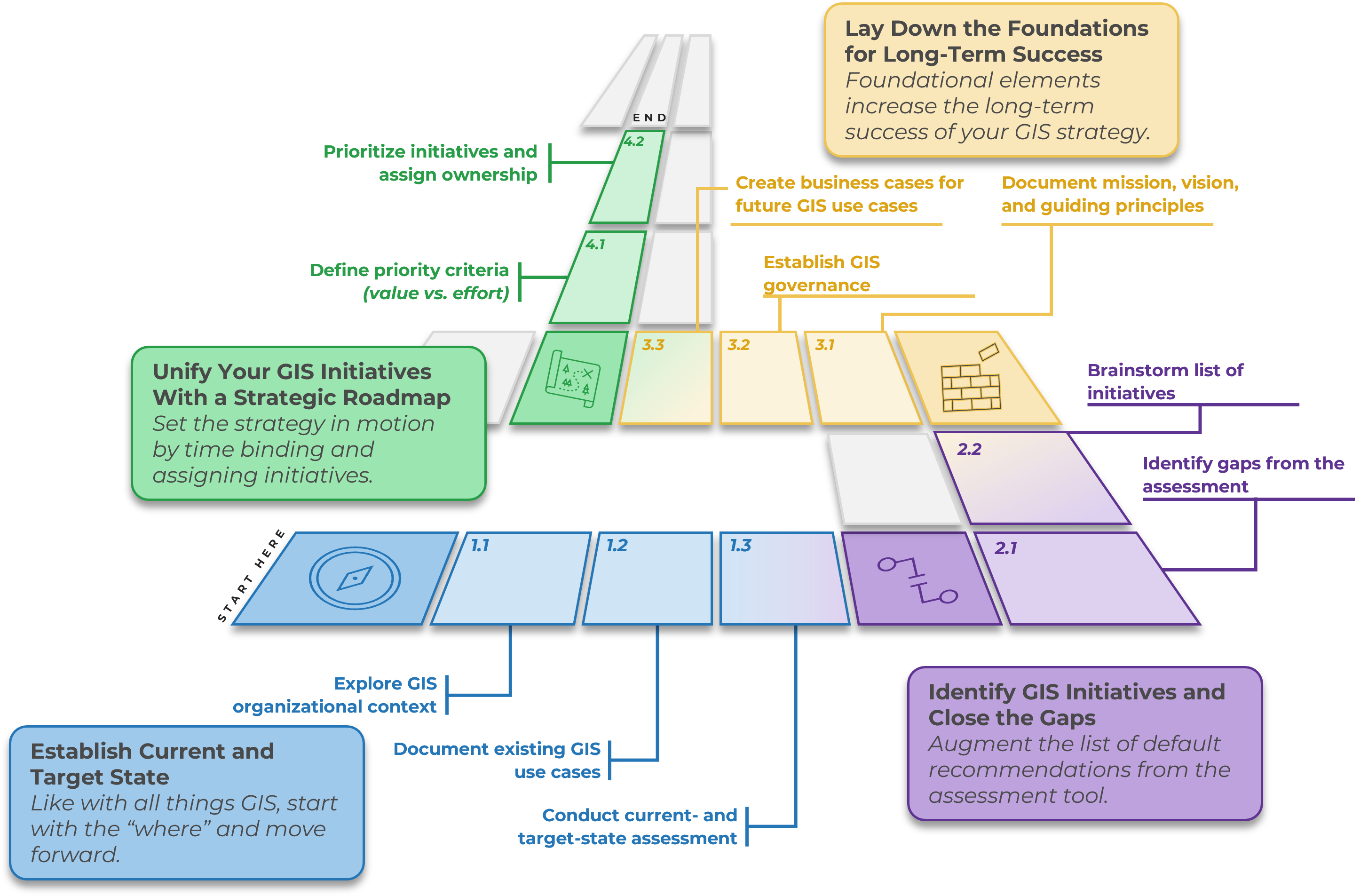
Info-Tech’s Approach
Develop a unified GIS strategy for your organization:
- Establish GIS Current and Target State – Assess your organization’s GIS maturity and aspirations.
- Conduct Gap Analysis and GIS Initiatives – Identify list of initiatives to achieve target state.
- Form GIS Foundations – Start by building GIS foundations (e.g. data, governance, priority use cases) based on best practices.
- Build Your GIS Roadmap – Operationalize the GIS strategy by prioritizing, assigning, and executing on the defined initiatives.
Info-Tech Insight
GIS holds immense benefits and value given the emerging technology (e.g. AI, IoT, 3D modeling, field mobility) and can transform the way utility organizations do business. Failure to unlock the true potential of GIS will put your organization behind your competitors and peers.
Your challenge
GIS offers immense value for utility organizations; realizing its full potential is often the main challenge.
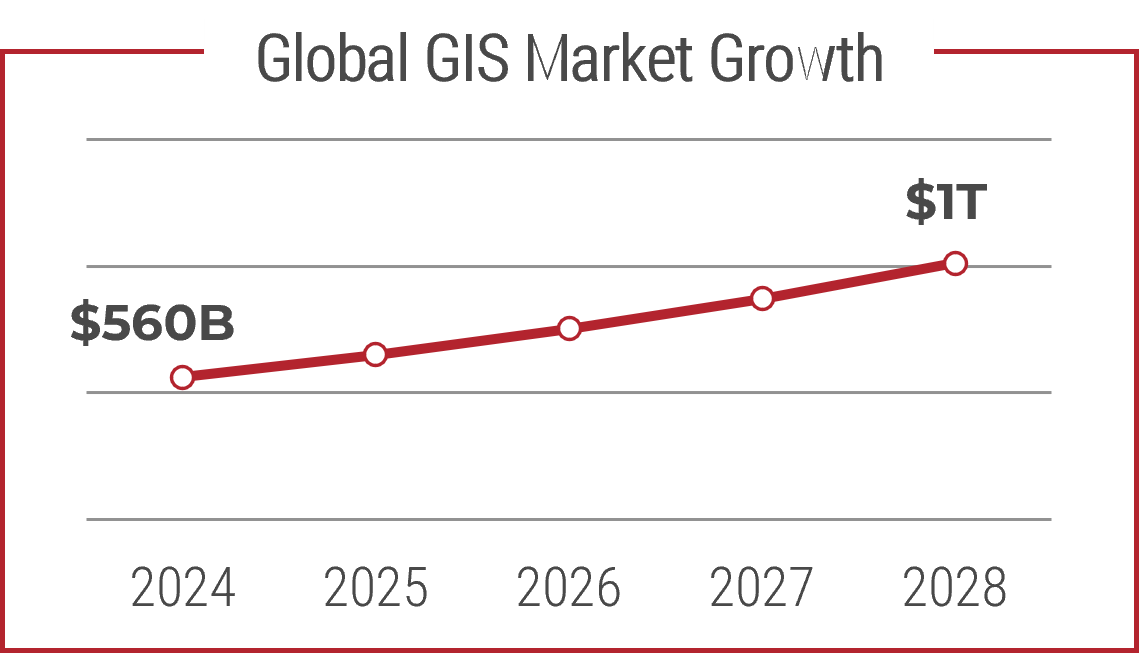
The global GIS market is valued at $560B in 2024 and is set to grow to $1T by 2028 (PwC, 2025) due to emerging technologies such as AI, IoT, drones, and smart meters. The utility industry (electricity, water, gas) accounts for 18% of this market share (PwC, 2025), signaling immense growth and investments. Utilities who harness the full value of GIS will have a competitive edge in the marketplace.
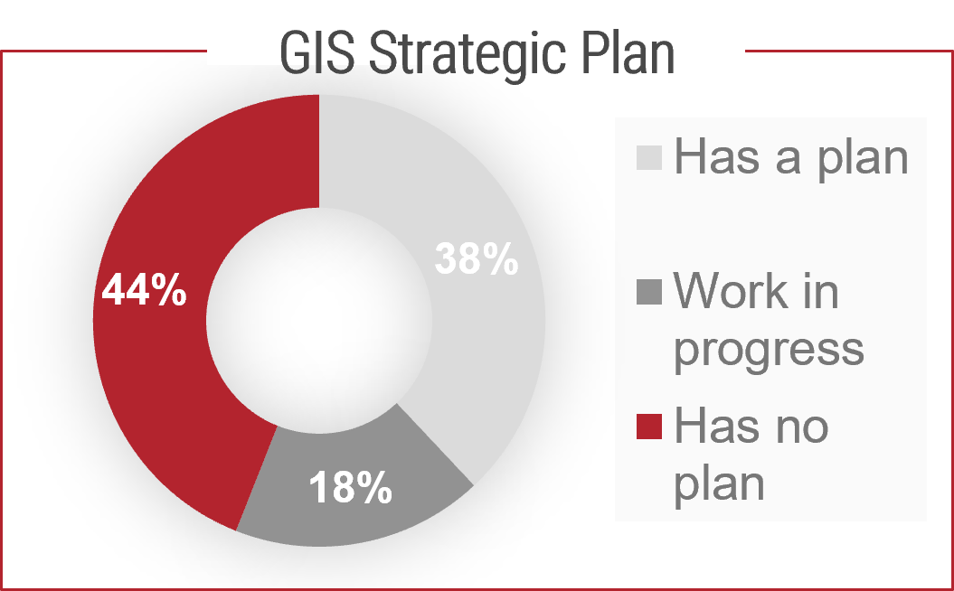
A Geospatial Maturity Index Report indicated 44% of organization (municipalities and utilities) had no GIS strategic plan (PSD Citywide, 2022), inhibiting advances beyond traditional departmental mapping. Often, the importance of GIS is recognized by only a small fraction of your organization and lacks endorsement across key stakeholders or departments.
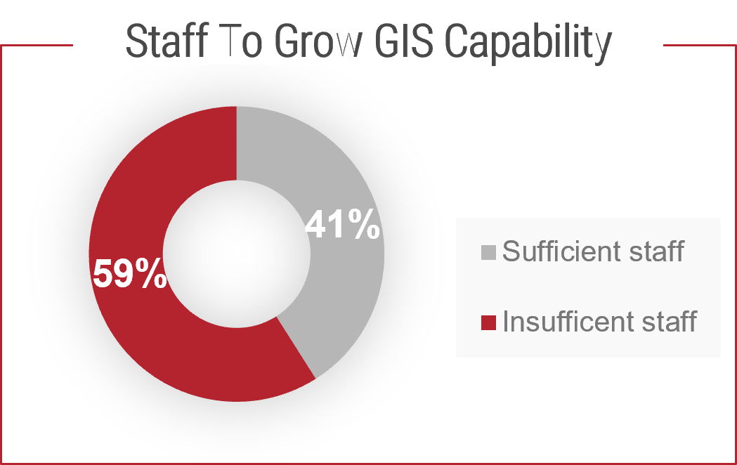
Only 41% of organizations stated they have sufficient number of staff to maintain their organization’s future GIS deliverables (PSD Citywide, 2022). Info-Tech members have indicated GIS talent is difficult to hire. The learning curve to understand an organization’s GIS configuration and processes are long, preventing individuals and departments from fully leveraging the capabilities of GIS.
Common obstacles
Utilities encounter recurring themes as they advance their GIS capabilities.
Disparate Geospatial Data
Disparate, fragmented GIS datasets across business units prevent a single source of truth and undermine operational workflows. When datasets use different identifiers, schemas, or update cadences, downstream systems (ADMS/SCADA/EAM) produce inconsistent results and engineers and crews lose confidence in maps used for critical decisions. Removing GIS data silos is a foundational step.
Lack of GIS Standardization and Policies
Absent or inconsistent GIS standards (naming, schema, projection, topology rules) and formal policies (metadata, access, versioning, security) lead to duplicated effort, stalled integrations, and poor data quality. Without enterprise standards, departments reinvent schemas and tools, duplicating effort, increasing customized solutions, and in the longer term, reducing adoption rate.
GIS Governance Limiting Collaboration
Like any other governance, GIS governance needs to be designed and right-sized for your organization’s constructs. Overly centralized bottlenecks business needs, and entirely decentralized creates siloes and impedes cross-functional collaboration. When governance lacks clear roles, funding paths, and an agreed-on roadmap departments are reluctant to share data or invest in enterprise capabilities.
Info-Tech’s approach
Assess your gaps, start with the foundations, and build a future roadmap.
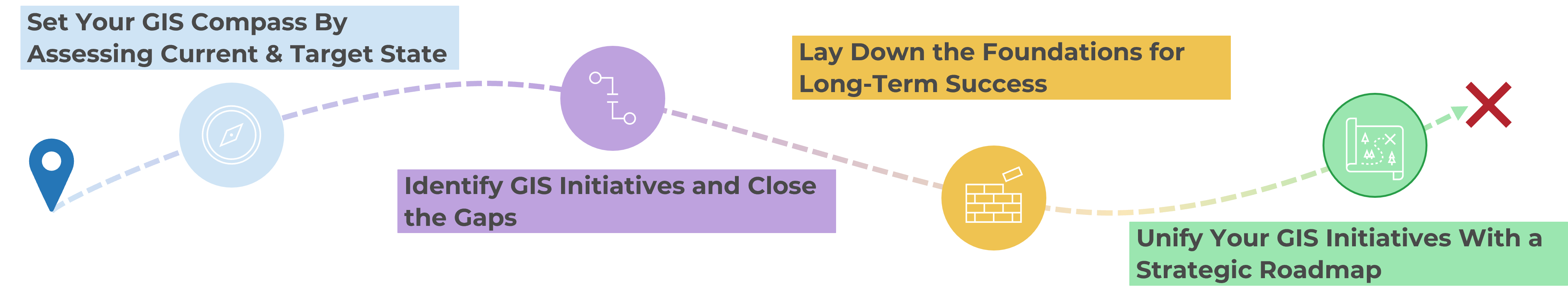
Set Your GIS Compass By Assessing Current & Target State
Evaluate your GIS capabilities across each of the strategic themes to assess the GIS maturity of your organization and where it aspires to be. The assessment will help you navigate focus areas and chart the path to elevate your GIS maturity.
Identify GIS Initiatives and Close the Gaps
Once the gaps are understood, the next step is to translate them into concrete initiatives against each of the strategic themes. The outcome is a well-defined set of projects, aligned to your broader organizational strategy.
Lay Down the Foundations for Long-Term Success
Focus on foundational areas supporting your organization’s enablement of GIS (e.g. data standards, procedures, governing committees) and aligned to best practices. These foundational elements ensure GIS remains accurate and well managed for years to come.
Unify Your GIS Initiatives With a Strategic Roadmap
Sequence all GIS initiatives into a coherent, multiyear roadmap that balances quick wins with foundational investments. The roadmap aligns projects with organizational priorities and resources and holds teams accountable for execution.
Develop a Business-Aligned GIS Strategy for Utilities
GIS plays a fundamental role in grid modernization; build your strategy today and reap the benefits of tomorrow.
The global GIS market is set to nearly double in four years, reaching $1T dollars by 2028, with electricity, gas, and water utilities accounting for 18% of that market (PwC, 2025). Prepare your organization to harness the maximum value through a right-sized GIS strategy and roadmap.
Problem:
GIS capabilities are developing at a rapid pace; Utilities need to keep in lockstep with the innovation or risk lagging behind their peers and losing the opportunity to gain a competitive edge in the market.
Challenges:
- Geospatial data is siloed across organization; the source of truth not recognized.
- Leadership fails to comprehend the value of GIS and its significance in grid modernization.
- Limited GIS resources and skills prevent innovation and advanced GIS use cases.
Solution:
No matter your organization’s GIS maturity, our tools and methodologies will help your organization develop a GIS strategy to meet future aspirations.
Benefits:
- Create a business-aligned GIS strategy that supports organizational goals.
- Enable the adoption of advanced GIS capabilities.
- Find productivity efficiencies through streamlining GIS processes and resources.
Insight map
GIS serves as a fundamental element for Utilities to reach their transformation objectives and enhance operational resilience.
Modern GIS platforms and capabilities deliver significant ROI, and the trend is only increasing. True value will be harnessed by aligning GIS to strategic objectives such as grid modernization, digital grid, asset management, and AI.
Like with all things GIS, start with “where”
Determine where you are in terms of your GIS journey; only then can you progress forward by developing a GIS strategy. Conducting a current and future state assessment is equivalent to building a compass for your GIS strategy.
Bridge the gap by building the foundations
The gap between the current and target state can be caused by a plethora of reasons, focusing on the foundational elements (e.g. data quality, integration infrastructure, governance, and people) will increase your chances of long-term success.
Unify your organization with a GIS roadmap
Strategies only work when there is stakeholder buy-in and everyone is aligned to a common objective. Chart a clear path to reach the GIS target state and hold individuals across your organization accountable.
Blueprint deliverables
Key deliverable
GIS Current and Target State Assessment Tool
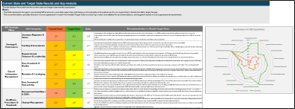
A comprehensive and easy-to-use tool to establish your organization’s GIS current- and target-state maturity across the six strategic themes and corresponding subcategories. The output of the tool will be a gap analysis identifying your existing strengths and weaknesses and recommendations to help close the gap.
GIS Initiative Prioritization and Roadmap Planning Tool
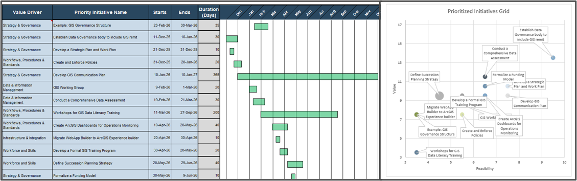
The roadmap tool will prioritize the GIS initiatives identified as part of the gap analysis according to your organization’s value vs. cost/effort requirements and chart a timebound roadmap for your GIS strategy.
Blueprint benefits
IT Benefits
Role of IT is shifting to a more custodianship role for GIS:
- GIS Data Rationalization: Reduce duplicated GIS databases and applications across departments, lowering maintenance costs.
- Improved IT/OT Integration: GIS is an opportunity for convergence, increasing collaboration between IT and OT.
- Agility in New Tech Adoption: IT can deploy innovative solutions (IoT, AI, Cloud GIS) on a stable foundation.
- Streamline Processes and Resources: Common policies and frameworks can be adopted in GIS realm, automating tasks and freeing up IT resources.
Business Benefits
Advantages are directly linked to the use case enablement of GIS:
- Higher Productivity: Utilities can achieve 30% reduction in maintenance expenditures and 20% decrease in urban development cost using reliable GIS data (CHCNAV, 2024).
- Strategic Enabler for Digital Grid: The transition to a digital grid allows for integration with GIS, SCADA, CMMS, and weather data to enable predictive analytics, anomaly detection, and real-time monitoring.
- Lower Operating Cost through rationalization of applications and streamlining of data and infrastructure.
Info-Tech Insight
In Utilities, GIS is an area where IT and OT convergence is occurring at a rapid pace. IT is taking more of a custodianship role in managing GIS, and OT and other business units are taking more accountability in the execution and deployment of GIS capabilities.

About Info-Tech
Info-Tech Research Group is the world’s fastest-growing information technology research and advisory company, proudly serving over 30,000 IT professionals.
We produce unbiased and highly relevant research to help CIOs and IT leaders make strategic, timely, and well-informed decisions. We partner closely with IT teams to provide everything they need, from actionable tools to analyst guidance, ensuring they deliver measurable results for their organizations.
What Is a Blueprint?
A blueprint is designed to be a roadmap, containing a methodology and the tools and templates you need to solve your IT problems.
Each blueprint can be accompanied by a Guided Implementation that provides you access to our world-class analysts to help you get through the project.
Need Extra Help?
Speak With An Analyst
Get the help you need in this 4-phase advisory process. You'll receive multiple touchpoints with our researchers, all included in your membership.
Guided Implementation 1: Establish Current and Target State
- Call 1: Introduce and level set on GIS strategic themes.
- Call 2: Conduct current and target state assessment via tool.
Guided Implementation 2: Conduct Gap Analysis and Identify GIS Initiatives
- Call 1: Review and align results, highlighting greatest gaps.
- Call 2: Identify list of GIS initiatives.
Guided Implementation 3: Form or Advance GIS Foundations
- Call 1: Define GIS mission, vision, and guiding principles.
- Call 2: Review and complete GIS governance, metrics, and KPIs.
Guided Implementation 4: Build Your GIS Roadmap
- Call 1: Define initiative prioritization criteria and complete roadmap.
- Call 2: Finalize roadmap and close out.